
Today, September 1, 2026, marks Disaster Prevention Day (防災の日) in Japan, kicking off a week-long nationwide campaign dedicated to disaster awareness. In recent years, as extreme weather driven by climate change has become the new normal and floods and landslides frequently strike across the country, a property's "disaster resilience" has emerged as one of the most critical factors dictating its asset value in the real estate market.
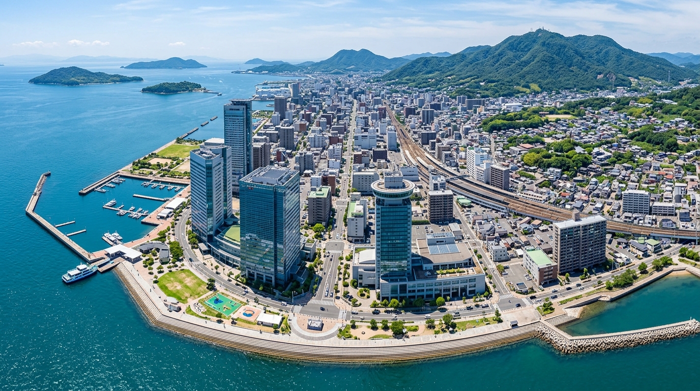
This article shines a spotlight on Takamatsu City, Kagawa Prefecture (香川県高松市), a core city facing the Seto Inland Sea (瀬戸内海). Currently, Takamatsu is undergoing massive redevelopment in its coastal Sunport Takamatsu (サンポート高松) area, rapidly transforming the face of the city. At the same time, driven by the ever-present threat of the Nankai Trough Megaquake (南海トラフ巨大地震) and the associated risks of storm surges and tsunamis in the Shikoku (四国) region, citizens' housing demands are steadily shifting southward toward inland areas, such as Busshozan (仏生山), Ota (太田), and further down to Kagawa-cho (香川町).
Using hard data such as the latest transaction records from the Ministry of Land, Infrastructure, Transport and Tourism (国土交通省) and hazard map information from the Geospatial Information Authority of Japan (国土地理院), this article provides an in-depth, professional real estate analyst's perspective on the current state of urban disaster prevention in Takamatsu and how shifting disaster risks are driving the latest trends in property values.
[Summary of Investment Insights in This Article]
- Coastal Polarization: While the redevelopment around Sunport Takamatsu is boosting its value as a commercial and business hub, implementing advanced Business Continuity Plan (BCP) measures against storm surge and tsunami risks has become absolutely essential.
- Rise of the Inland Southward Shift: Heightened disaster awareness is driving a clear shift in housing demand toward Busshozan, Ota, and the more southern Kagawa-cho areas. A diverse range of transactions, from brand-new builds to older properties, is picking up pace.
- Coexistence of Compact City Living and Hazards: Popular educational districts around Ritsurin Garden (栗林公園) maintain solid demand. However, even inland areas face risks of river flooding and landslides, making localized hazard map checks an absolute prerequisite for any investment.
1. Introduction: The 2026 Disaster Prevention Week and the Real Estate Environment in Takamatsu City
When considering real estate investments or home purchases today, evaluating a property's "disaster resilience" alongside its location and convenience has become the modern standard. Takamatsu City is blessed with a rich natural environment, bordered by the calm Seto Inland Sea to the north and the Sanuki Mountains (讃岐山脈) to the south. However, these geographical traits mean the city constantly lives alongside the risks of storm surges and tsunamis on the coast, as well as river flooding and landslides inland and near the mountains.
To grasp the big picture of Takamatsu's real estate market, let's first look at the latest actual transaction data (covering 2021–2025) obtained through the Mekiki Research (物件目利きリサーチ) system.
Table 1: Real Estate Transaction Statistics for Takamatsu City, Kagawa Prefecture (Period: 2021–2025)
| Item | Data Result | Notes |
|---|---|---|
| Target Area | Takamatsu City, Kagawa Prefecture (City Code: 37201) | - |
| Sample Size | 5,843 transactions | Data volume indicating sufficient liquidity |
| Average Transaction Price | Approx. 20.19 million JPY | - |
| Median Transaction Price | 11.00 million JPY | Includes many transactions of older properties and land-only deals |
| Price Range | 100 JPY – 1.1 billion JPY | - |
| Average Unit Price | Approx. 48,000 JPY / ㎡ | Extreme polarization depending on the area |
This massive sample of 5,843 transactions shows that Takamatsu's real estate market is highly active. The average transaction price is around 20.19 million yen, but the median sits at just 11 million yen. This indicates a massive price gap between a handful of high-value commercial properties and new builds in the city center, and inexpensive land or older second-hand properties in the suburbs. The average unit price is roughly 48,000 yen per square meter, which again shows a stark divergence between urban and suburban areas.
As we mark Disaster Prevention Week, the following chapters will explore exactly how the underlying "wariness of disaster risks" in this active market is rerouting the flow of capital and housing demand.
💡 Analyst's Perspective Once you understand the overall market trends in Takamatsu, I highly recommend checking pinpoint transaction data for comparable properties in your specific target area to get a more accurate feel for local pricing.
2. The Full Picture of Sunport Takamatsu Redevelopment and Coastal Storm Surge/Tsunami Risks
The Sunport Takamatsu area, located north of JR Takamatsu Station (JR高松駅) at the gateway to the city, is currently undergoing a massive redevelopment project on a scale rarely seen in recent years. As of 2026, the full scope of this transformation is becoming clear.
[Sunport Takamatsu Redevelopment Timeline (From Groundbreaking to Scheduled Completion)]
- 2021–2023: Ground preparation and infrastructure restructuring for the new station building development.
- 2024: Opening of TAKAMATSU ORNE (タカマツ オルネ), a commercial complex directly connected to JR Takamatsu Station.
- 2025: Completion and opening of the New Kagawa Prefectural Arena / Anabuki Arena Kagawa (新香川県立アリーナ / あなぶきアリーナ香川), one of the largest arenas in the Chugoku and Shikoku regions (中四国).
- 2025–2026: Final stages of construction for foreign luxury hotels (such as Mandarin Oriental (マンダリンオリエンタル)), solidifying the area's role as an international tourism and MICE hub.
As you can see, Sunport Takamatsu holds overwhelming potential to drive business and tourism in Shikoku. However, when evaluating long-term real estate value, "storm surge and tsunami risks" are an unavoidable reality.
The coastal areas of Takamatsu, including Sunport, sit at a low elevation and have a history of storm surge damage from typhoons. Furthermore, in the event of a Nankai Trough Megaquake, tsunamis are projected to travel through the Seto Inland Sea and strike the area. While the redevelopment is bringing glamorous new facilities, investors and developers are conducting strict risk assessments, treating these assets as "properties within projected inundation zones."
Coastal real estate inherently carries a "high risk, high return" profile—offering high profitability in normal times but catastrophic risks during emergencies. This requires investment decisions that go far beyond simple yield calculations.
💡 Analyst's Perspective While commercial land around redevelopment areas offers promising future capital gains, the risks outlined on hazard maps cannot be entirely offset. It is crucial to evaluate properties in tandem with the latest inundation projections.
3. Latest Infrastructure Upgrades and BCP Measures for Corporate Attraction in Coastal Areas
Given the acknowledged risks of the coastal areas, why are such massive investments pouring into Sunport Takamatsu? The answer lies in robust Business Continuity Plan (BCP) measures and infrastructure resilience spearheaded by public-private partnerships.
New development projects like the New Kagawa Prefectural Arena and foreign luxury hotels incorporate exceptionally high levels of disaster prevention features right from the design phase. For instance, it has become standard practice to place critical electrical equipment and emergency generators on upper floors, ensuring that even if the ground floor is flooded by a tsunami or storm surge, the facility remains operational. Urban planning also includes seawall reinforcements and the integration of temporary evacuation functions, such as securing vertical evacuation routes via pedestrian decks.
It is precisely because of these thorough infrastructure upgrades that companies can confidently establish operations on the coast. Takamatsu serves as the nerve center for branch office economies in Shikoku. Increasingly, companies are choosing to lease space in high-grade, BCP-equipped office buildings in the Sunport area rather than owning their own standalone buildings.
In other words, we have entered an era where the value of coastal real estate is rated not just by the "presence of hazards," but by the "physical and systemic capacity of the building to withstand those hazards."
💡 Analyst's Perspective When considering investments in corporate office buildings or commercial facilities, the physical disaster-prevention specs of the property directly impact tenant attraction. A detailed inquiry into the building's disaster prevention equipment is essential.
4. How Hazard Map Inundation Projections Drive Land Price Trends in Takamatsu
While the coastal areas leverage cutting-edge technology to control risks, consumer behavior in the general housing market is far more cautious. The psychological sentiment of "there's no need to live in a risky area if you don't have to" is directly shaping land price trends, heavily influenced by hazard maps.
Let's look at the transaction price trends within Takamatsu City based on actual data.
The graph above plots prices of actual samples acquired by our system, showing an incredibly wide distribution ranging from 1 million to 20 million yen.
What is crucially important here is the hazard information that the system warns about when acquiring a property. In our recent data pull, the following risks were clearly detected for the target areas:
- Flood Risk: Present (Max Inundation Depth Rank 2: 0.5 to 3 meters)
- Landslide Risk: Present (Phenomenon: Debris flow)
Even in inland areas, the basins of major rivers like the Koto River (香東川), Shin River (新川), and Kasuga River (春日川) have widespread projected inundation zones of "Flood Rank 2 (0.5–3m)" due to heavy rains. Move closer to the mountains, and the risk of sediment disasters like debris flows becomes apparent. Checking this hazard information before buying or investing in real estate is no longer just a strong recommendation—it is an absolute prerequisite.
In Takamatsu today, land prices in "uncolored" (low-risk) areas on hazard maps are rising relatively fast, while prices in heavily colored areas are stagnating. We are seeing a clear stratification of land values based on safety.
💡 Analyst's Perspective Be sure to check not just historical disaster records, but the latest hazard maps that factor in climate change. Properties in hazard zones carry a high risk of struggling during a future sale (exit strategy).
5. Rapid Shift in Housing Demand to the Inland Southward Areas (Busshozan and Ota)
To avoid coastal tsunami risks, housing demand among Takamatsu citizens has rapidly shifted inland in recent years. The Ota and Busshozan areas have been particularly popular, but surging land prices and a shortage of available lots are now pushing demand even further south toward Kagawa-cho.
The actual data we pulled this time includes numerous transaction records from the Kagawa-cho Ono (香川町大野) area, perfectly substantiating this southward trend.
Table 2: Actual Transaction Sample Analysis for the Kagawa-cho Ono Area (Q1 2021)
| Property Type | Area (㎡) | Year Built | Transaction Price | Unit Price Equivalent | Zoning District |
|---|---|---|---|---|---|
| Residential (Land & Building) | 175 | 2021 | 20.00 million JPY | - | Category I Residential Zone |
| Residential (Land & Building) | 1,400 | 1986 | 14.00 million JPY | - | Quasi-Residential Zone |
| Residential (Land) | 210 | - | 6.50 million JPY | Approx. 31,000 JPY / ㎡ | Outside Urbanization Promotion Area |
| Residential (Land) | 160 | - | 4.00 million JPY | Approx. 25,000 JPY / ㎡ | Industrial Zone |
| Residential (Land & Building) | 120 | 1976 | 1.00 million JPY | - | Category II Mid/High-Rise Residential |
From this data, we can read that the real estate market in Kagawa-cho Ono is highly diverse and active. First, a brand-new detached house built in 2021 (175㎡) sold for 20 million yen, showing that the area is absorbing young families looking for affordable new homes. On the other end of the spectrum, an older detached house built in 1976 (120㎡) transacted for just 1 million yen, suggesting active circulation of vacant homes and purchases made with renovation in mind. Furthermore, a transaction for a massive 1,400㎡ plot with a building (built in 1986) went for 14 million yen, highlighting the demand for spacious living environments that only the suburbs can offer.
Looking at land-only deals, unit prices sit at a very reasonable 25,000 to 31,000 yen/㎡ compared to the city center. Buyers priced out of Ota and Busshozan are seeking a balance between peace of mind regarding disasters and affordability, triggering a "southward domino effect" where they build their homes in the Kagawa-cho area—a trend clearly proven by the hard data.
💡 Analyst's Perspective When considering investments or residential purchases in suburban areas, targeting neighborhoods experiencing a turnover between old and new residents (areas with diverse transaction types) makes it easier to secure future liquidity.
6. Progress Toward a Compact City Centered Around the Kotoden Railway Lines
Takamatsu City is actively promoting the formation of a "Multi-Polar Network-Type Compact City." This strategy aims to curb urban sprawl by concentrating city functions in the center and along public transportation routes. The backbone of this network is the rail infrastructure, including JR and the local beloved Kotoden / Takamatsu-Kotohira Electric Railroad (ことでん / 高松琴平電気鉄道).
The environmental data we pulled includes attractive infrastructure information for an area just outside the city center:
- Nearest Station: Ritsurin-Koen-Kitaguchi Station on the JR Kotoku Line (JR高徳線「栗林公園北口」駅) (Average daily ridership: 934)
- School District: Kameoka Elementary School (亀阜小学校), Shiun Junior High School (紫雲中学校)
- Medical Facilities: 21 locations (including Takamatsu Red Cross Hospital (高松赤十字病院), Gobancho Clinic (五番丁医院), Manabe Clinic (医療法人社団真鍋医院), etc.)
- Zoning: Category I Mid/High-Rise Exclusive Residential District (Building Coverage Ratio 60%, Floor Area Ratio 200%)
The area around Ritsurin-Koen-Kitaguchi Station is adjacent to Ritsurin Garden, a Special Place of Scenic Beauty, blending natural environments with urban convenience. The Kameoka Elementary and Shiun Junior High school districts, in particular, are known as some of the most highly sought-after educational zones in Takamatsu, boasting rock-solid demand from families with children. Moreover, the dense concentration of 21 clinics and hospitals in the vicinity—anchored by a highly advanced medical institution like the Takamatsu Red Cross Hospital—serves as a massively powerful draw (and value-retention factor) for the area in an aging society.
While demand is shifting toward the suburbs (Kagawa-cho direction), the asset value of central and near-central areas equipped with such robust medical, educational, and transportation infrastructure will remain unshaken, buoyed by the tailwinds of the city's compact city policies.
💡 Analyst's Perspective "Station ridership," "prestigious school districts," and "the presence of general hospitals" are the three major pillars supporting real estate value. Always check these environmental data points quantitatively when selecting a property.
7. The Latest Real Estate Investment Strategies in Takamatsu: Balancing Disaster Resilience and Asset Value
Taking into account the coastal redevelopment, the inland demand shift, and the progression of compact city planning we've discussed so far, let's summarize the latest strategies for investing in and purchasing real estate in the Takamatsu area.
Our actual data also included a transaction from Kanko-cho (観光町), located on the eastern side of central Takamatsu:
- Used Condominium (Kanko-cho): Area 65㎡ (3LDK), Built in 1988, Transaction Price 7.9 million JPY, Neighborhood Commercial Zone (Building Coverage 80%, Floor Area Ratio 300%)
A condominium over 30 years old traded for 7.9 million yen. The ability to acquire a 3LDK layout for under 10 million yen while enjoying near-downtown convenience is highly attractive to both end-users and investors (e.g., for renting out after renovation).
[Future Investment Strategies for the Takamatsu Area]
- Targeting Families for End-Use: Developing land and detached homes in the "southward shift area" stretching from Busshozan and Ota down to Kagawa-cho. The key is pinpointing locations that avoid hazard risks (river flooding and landslides).
- Targeting Income Gains (Rental Yields): Investing in renovations of older condominiums in "educational districts" like those zoned for Kameoka/Shiun, or "medically rich areas" near the Takamatsu Red Cross Hospital.
- Targeting Capital Gains (Profit from Sale): Commercial real estate along the coast and around Takamatsu Station, set to benefit from the Sunport Takamatsu redevelopment. However, this is for advanced investors, as it requires accepting inundation risks and implementing sophisticated BCP measures.
In Takamatsu, where disaster risks intersect with the dynamism of urban development, winning consistently with a single strategy is difficult. More than ever, investors need a "discerning eye" to cross-reference macro urban planning (the compact city) with micro transaction data (unit prices and building age), all while keeping a hazard map close at hand.
💡 Analyst's Perspective Diversifying your investment areas is the ultimate risk hedge. Consider balancing your portfolio by combining, for example, a condominium unit on the coast with a detached rental home inland.
8. Conclusion: A Next-Generation Urban Model Coexisting with Disaster Risks
In honor of the 2026 Disaster Prevention Week, we have examined the latest real estate landscape in Takamatsu City, Kagawa Prefecture.
While the glamorous redevelopment of Sunport Takamatsu is elevating the city's economic value, a healthy respect for natural threats like storm surges and tsunamis is definitively steering citizens' housing choices toward the inland, southward areas. As the actual transaction data from Kagawa-cho Ono shows, diverse housing demand on safe suburban land will continue to thrive. At the same time, core areas of the compact city with excellent infrastructure, such as the neighborhoods around Ritsurin Garden, will continue to maintain high asset values.
Real estate value is no longer determined solely by "distance from the station" or "curb appeal." Accurately assessing unseen disaster risks (hazards) and factoring them into pricing is the most critical theme in modern real estate transactions. As a "next-generation regional city model" where disaster risk and urban development coexist, Takamatsu City will undoubtedly continue to draw attention from across the country.
We hope you will use the objective, data-driven analysis presented in this article to inform your own investment decisions and home-buying journeys.
By registering for a free account, you can pull the Ministry of Land, Infrastructure, Transport and Tourism data used in this blog directly from your Claude or ChatGPT (via MCP integration). Get the environment you need to seamlessly continue your research with your own AI and achieve even more precise property selection.