
As we approach "Disaster Prevention Week (防災週間)" in 2026, evaluating urban disaster preparedness and hazard risks has become a more crucial factor than ever for investment decisions in the Japanese real estate market. Particularly as the probability of a Nankai Trough Megaquake (南海トラフ巨大地震) increases, real estate trends in regional core cities with designated tsunami inundation zones serve as excellent model cases for reconsidering the balance between risk and return.
Based on the latest actual transaction data (covering 2021–2025) for Tokushima City, Tokushima Prefecture (徳島県徳島市), this article provides an in-depth analysis of inundation risks in the central commercial district and the reality of demand shifting toward inland elevated areas. Key investment insights derived from this article include:
- Materialization of Hazard Risks: The central area of Tokushima City and the Yoshino River (吉野川) estuary face flood and tsunami inundation risks of up to 3 to 5 meters, making pre-purchase hazard verification an absolute prerequisite.
- Demand Shift to Inland Elevated Areas: There is a pronounced demand for relocating housing and corporate hubs (for BCP - Business Continuity Planning purposes) to inland areas with lower tsunami risks, such as around Myodocho (名東町) and Kokufucho (国府町).
- Polarization of Real Estate Value: Investors' evaluation criteria are shifting significantly between the convenience of commercial zones (400% floor area ratio) and the safety of suburban Urbanization Control Areas (市街化調整区域).
1. 2026 Disaster Prevention Week: Nankai Trough Tsunami Projections and the Current State of Urban Disaster Preparedness
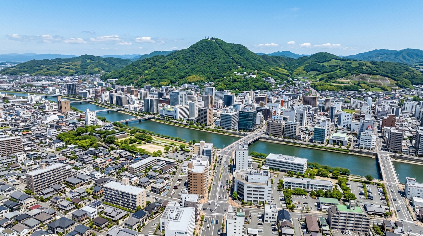
In major Japanese cities, developing disaster prevention infrastructure and the subsequent revaluation of real estate has been positioned as a national priority. Tokushima City, in particular, has its central commercial district built on the vast estuary delta of the Yoshino River, creating a topography that exists side-by-side with the risk of tsunamis triggered by a Nankai Trough Megaquake and flooding from severe typhoons.
The table below provides a summary of recent real estate transactions in Tokushima City, obtained through the "Bukken Mekiki Research (物件目利きリサーチ)" system.
| Metric | Data Details (Period: 2021–2025) |
|---|---|
| Survey Area | Tokushima City, Tokushima Prefecture |
| Total Transactions | 2,968 |
| Average Transaction Price | Approx. 20.3 million JPY (20,303,752 JPY) |
| Median Transaction Price | 13 million JPY |
| Price Range | 500 JPY – 1.4 billion JPY |
| Average Unit Price | Approx. 58,000 JPY/sqm |
| Hazard Information | Flood Risk: Yes (Max inundation depth: 3–5m) / Landslide Risk: No |
What can be gleaned from this data is a market skew: while there is an active market with over 2,900 transactions, there is a divergence between the average transaction price (approx. 20.3 million JPY) and the median (13 million JPY), driven by a few large-scale transactions (up to 1.4 billion JPY) pulling up the average. Furthermore, the entire surveyed area has a projected "maximum inundation depth of 3–5m," highlighting severe flood and tsunami risks. This underscores that urban disaster preparedness is an indispensable perspective for B2B real estate investment and corporate site selection.
2. Latest Verification of Inundation Risks in Central Tokushima City (Yoshino River Estuary, Okinohama Area, etc.)
When evaluating real estate value, the metric in question is not just location convenience, but resilience—how safe the location actually is. According to the latest hazard data, while landslide risk in central Tokushima City is classified as "No (no registered phenomena)," flood risk is evaluated as "Yes," with the maximum inundation depth reaching the "3–5m" tier.
This means that in the event of a massive tsunami triggered by a Nankai Trough earthquake or Yoshino River flooding due to unprecedented torrential rain, ordinary two-story wooden houses could be completely submerged up to the second floor. Therefore, for investors and developers considering property acquisition or development in this area, checking the latest hazard map prior to purchase is an absolute necessity, a point we strongly urge our readers to heed.
Because this 3–5m inundation risk is a given, new developments in the city center are increasingly standardizing designs that place electrical equipment and critical infrastructure on the second floor or higher, as well as condominium developments employing piloti (ピロティ) structures. Hazard risk is no longer merely a negative factor; it is beginning to be priced into real estate values as necessary construction costs for adaptation (a risk premium).
3. The Impact of Tsunami Hazard Maps on Real Estate Values and Development Plans in the Central Commercial District
The central commercial district of Tokushima City is the core of its urban functions, hosting administrative bodies and commercial facilities. Actual data shows that the central area has zoning designations allowing for high-density utilization, such as "Zoning: Commercial Zone," "Building Coverage Ratio: 80%," and "Floor Area Ratio: 400%." Additionally, around Awa-Tomida Station (阿波富田駅) on the Shikoku Railway Company (JR Shikoku / 四国旅客鉄道) line (daily ridership: 850), there is consistent real estate demand tied to compact city policies.
However, as mentioned earlier, this area exists back-to-back with tsunami and flood risks. From an investor's perspective, the high development potential of a 400% floor area ratio in a commercial zone is attractive, but at the same time, the initial investment required for flood mitigation measures and increased insurance premiums act as factors that compress yields.
For example, a transaction from the first quarter of 2021 for a pre-owned condominium (Use: Residential, built in 1985, 1DK, area 20 sq.m.) in the Atake district (安宅地区) was priced at 1.9 million JPY. This property is located in a "Quasi-industrial zone (準工業地域) (Building Coverage Ratio: 60%, Floor Area Ratio: 200%)." Given its older construction age and small scale within a hazard zone, it is inferred that there is heavy resistance against asset appreciation. Furthermore, since unit price information for this transaction is null, and the area lacks deep public transaction data, rigorous comparison with neighborhood market rates is essential when making investment decisions.
4. The Shift in Housing and Corporate Hub Demand to Inland Elevated Areas (Around Myodocho and Kokufucho)
As inundation risks in the central commercial district become widely recognized, a clear "geographic shift in demand" is occurring in Tokushima City's real estate market. This is manifested as growing interest in inland elevated areas, particularly around Myodocho and Kokufucho.
Two strong vectors are at play: the relocation of offices and logistics hubs by companies prioritizing Business Continuity Planning (BCP), and the securing of safe residential land by actual homebuyers. Looking at real transaction samples, it is evident that transactions in suburban areas are accelerating.
For instance, in land transactions during the first quarter of 2021 in Kawauchicho (川内町), a 230 sq.m. residential plot sold for 5.6 million JPY (approx. 24,000 JPY/sq.m.), and a 260 sq.m. plot sold for 7.5 million JPY (approx. 29,000 JPY/sq.m.). Additionally, a vast 1,100 sq.m. plot in Otanicho (大谷町) was transacted for 21 million JPY (approx. 19,000 JPY/sq.m.).
It is noteworthy that many of these lands are designated as "Urbanization Control Areas (市街化調整区域) (Building Coverage Ratio: 70%, Floor Area Ratio: 200%)." Originally, Urbanization Control Areas are zones where development is strictly restricted. However, data starkly reveals that the buying and selling of existing residential lots and development activities meeting specific conditions are steadily progressing to absorb the demand that prioritizes safety.
5. Quantifying Hazard Risks in B2B Real Estate Investment and Leveraging "Bukken Mekiki Research"
In business-to-business (B2B) real estate transactions and portfolio construction by institutional investors, quantifying hazard risks is now an unavoidable process. In a market like Tokushima City, where the average transaction price is around 20.3 million JPY yet large transactions of up to 1.4 billion JPY exist, micro-locational conditions decisively influence pricing.
Safety is not the only factor underpinning real estate value; the robustness of local amenities and infrastructure is equally crucial. According to the obtained data, the targeted area is well-equipped with educational institutions (school districts) such as Shinmachi Elementary School (新町小学校) and Tomida Junior High School (富田中学校), anticipating solid demand from families.
Furthermore, the concentration of medical facilities is worth noting. There are a total of 39 medical institutions in the area, forming a network that includes core hospitals like Fukuda Orthopedic Hospital (福田整形外科病院) and Nakasu Yagi Hospital (中洲八木病院), as well as clinics like the Local Public Service Workers' Mutual Aid Association Tokushima Branch Clinic (地方職員共済組合徳島県支部直営診療所). In an aging Japan, such abundant healthcare infrastructure serves as an extremely powerful support factor for real estate values. Investors must weigh the downsides of flood risks against the upsides of these infrastructure enhancements to perform precise yield calculations.
In some samples (such as a 100 sq.m. land and building in Omatsucho (大松町) for 3.5 million JPY), unit prices or per-square-meter prices are occasionally recorded as null. Even with such missing data, utilizing the "Bukken Mekiki Research" system allows investors to cross-reference similar nearby transactions and the quality of medical and educational infrastructure, making it possible to estimate the validity of actual market prices with high accuracy.
6. Future Disaster Prevention Infrastructure Development and Resilience Enhancement Initiatives in Tokushima City
When discussing the future of the real estate market in Tokushima City, the trends in disaster prevention infrastructure development by the government—both in terms of hard and soft measures—cannot be ignored. Measures to boost the resilience of the entire city are progressing rapidly. These include constructing robust levees in the Yoshino River basin, building tsunami evacuation towers, and designating existing sturdy RC (Reinforced Concrete) structures (such as multi-story parking garages of commercial facilities) as tsunami evacuation buildings.
As seen in the earlier mentioned transaction of a pre-owned home (built in 1978, wooden, area 165 sq.m., Building Coverage Ratio: 60%, Floor Area Ratio: 200%) in a "Category I mid/high-rise oriented residential zone (第1種中高層住居専用地域)" in Kawauchicho for 7 million JPY, transactions of wooden houses built under old seismic design standards (旧耐震基準) still exist. Promoting seismic retrofitting for these properties and expanding subsidy programs for inundation-proofing renovations will be a vital key to revitalizing the existing stock market going forward. For developers, this suggests that beyond just building new construction, significant business opportunities lie in "renovation businesses that add value through disaster resilience."
7. Tokushima Area Real Estate Market Forecast Toward 2030 and New Development Potential
From 2026 to 2030, Tokushima City's real estate market will undergo a paradigm shift characterized by "risk visualization" and "relocation to suitable areas."
In the central commercial district, the mainstream will likely shift toward "three-dimensional risk-avoidance hybrid developments." These utilize the high potential of the 400% floor area ratio by designing lower floors as piloti or waterproofed commercial tenant spaces, while allocating mid-to-high floors for residences or offices. In areas functioning as transportation nodes, such as around Awa-Tomida Station, investments in such high-value-added residences will continue to be highly anticipated.
On the other hand, inland elevated areas like Kokufucho and Myodocho will enter a phase of evolving from mere "evacuation destinations" into "new hub cities." If discussions on deregulating Urbanization Control Areas progress, these areas hold the potential to generate unprecedented real estate demand, such as large-scale logistics facilities, data centers, and environmentally friendly smart town developments. Considering future development headroom, the current price level of approximately 58,000 JPY/sqm on average can still be evaluated as an attractive investment level compared to other regional cities nationwide.
8. Conclusion: Restructuring Tokushima City's Real Estate Value Brought by the Implementation of Urban Disaster Preparedness
Reviewing the latest data for Tokushima City ahead of the 2026 Disaster Prevention Week reveals the reality that tsunami projections for a Nankai Trough Megaquake (inundation risks of up to 3–5m) are beginning to be deeply priced into the real estate market.
The roughly 3,000 transaction data points from 2021 to 2025 vividly reflect a polarizing market: a movement seeking coexistence with hazard risks in the central commercial district, and a safety-driven demand shift toward inland elevated areas. In B2B real estate investment and corporate site selection, the ultimate metric determining future real estate value will no longer be limited to traditional specs like zoning and floor area ratios, but will focus on the question: "Does this location possess the resilience to protect lives and businesses?"
An approach based on the latest, objective data is always essential for analyzing the real estate market. By registering for a free membership, you can pull detailed data from sources like the Ministry of Land, Infrastructure, Transport and Tourism, as used in this blog, directly from your Claude or ChatGPT (via MCP integration). We highly encourage you to utilize this feature, which allows you to seamlessly continue your research within your own AI environment, to aid in your investment decisions.